Sign In | Join Free | My himfr.com
Home > Earthquake Rescue Equipment >

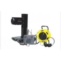
PSR-1000J 1km Disaster Rescue Equipment Portable Sudden Geological Disaster Monitoring Radar

Beijing  Topsky  Century Holding Co.,Ltd
Trust Seal
Verified Supplier
Credit Check
Supplier Assessment
Contact Now
    Buy cheap PSR-1000J 1km Disaster Rescue Equipment Portable Sudden Geological Disaster Monitoring Radar from wholesalers
     
    Buy cheap PSR-1000J 1km Disaster Rescue Equipment Portable Sudden Geological Disaster Monitoring Radar from wholesalers
    • Buy cheap PSR-1000J 1km Disaster Rescue Equipment Portable Sudden Geological Disaster Monitoring Radar from wholesalers
    • Buy cheap PSR-1000J 1km Disaster Rescue Equipment Portable Sudden Geological Disaster Monitoring Radar from wholesalers
    • Buy cheap PSR-1000J 1km Disaster Rescue Equipment Portable Sudden Geological Disaster Monitoring Radar from wholesalers
    • Buy cheap PSR-1000J 1km Disaster Rescue Equipment Portable Sudden Geological Disaster Monitoring Radar from wholesalers
    • Buy cheap PSR-1000J 1km Disaster Rescue Equipment Portable Sudden Geological Disaster Monitoring Radar from wholesalers

    PSR-1000J 1km Disaster Rescue Equipment Portable Sudden Geological Disaster Monitoring Radar

    Ask Lasest Price
    Brand Name : TOPSKY
    Model Number : PSR-1000J
    Price : USD50000
    Payment Terms : T/T
    Supply Ability : 20 Sets/Month
    Delivery Time : 10 working days
    • Product Details
    • Company Profile

    PSR-1000J 1km Disaster Rescue Equipment Portable Sudden Geological Disaster Monitoring Radar


    1.Product Overview
    The PSR-1000J portable sudden geological disaster monitoring radar adopts large-scale MIMO array technology and advanced moving target detection algorithm, and integrates radar, sound and light alarm and other technical means to form a portable sudden geological disaster alarm system. It can continuously monitor large-scale slopes and provide real-time alarms for rolling stones, mudslides, and collapses. It has the advantages of good environmental adaptability, wide coverage, fast updates, fast positioning, and meets the needs of individual soldiers.
    2.Scope of Application

    Open pit mines, geological landslides/collapses, emergency rescue, water conservancy dams, urban subsidence

    Subway transportation, large bridges, high-rise buildings, wind turbine towers, railway slopes

    3.Product Features

    • Adopting active microwave technology, it can work 24/7 without being affected by weather conditions such as rain, snow, fog, strong light, night light, etc., and has good environmental adaptability;
    • Adopting a solid-state electric scanning radar system, it can simultaneously cover 90 °× 30 ° scenes, with no mechanical moving parts during operation, a data update rate of seconds, higher reliability, and easy maintenance;
    • Equipped with a satellite compass, it can quickly obtain the accurate position coordinates and orientation of the radar, simplifying user operations;
    • Equipped with a two-dimensional gimbal, supporting radar horizontal 360 ° and adjustable pitch 90 °;
    • The whole machine adopts an integrated lightweight and low-power design, with a weight not exceeding 6kg and a power consumption not exceeding 30W, making it easy to transport and deploy;
    • Equipped with an electrical control box or router, capable of achieving 4G/WiFi communication;
    • The display and control software adopts B/S architecture and can be deployed on standalone or cloud servers. It adopts a fully Chinese interface, with rich parameter settings and simple and intuitive operation;
    • 3D terrain data can be imported online, and the position and trajectory of rolling stones can be directly overlaid and displayed on the 3D terrain base map;
    • Alarm zones and thresholds can be set, with on-site sound and light alarms and other alarm methods. Distributed sound and light alarm linkage can be achieved through the Internet of Things.
    4.Main Technical Parameters

    4.1 Host Parameters:

    • Maximum distance: ≥ 1000m
    • Electric scanning coverage angle: 120 ° (horizontal) × 30 ° (pitch)
    • gimbal coverage angle: 360 ° (horizontal) × 90 ° (pitch)
    • Angle measurement accuracy: ≤ 1 °
    • Distance measurement accuracy: ≤ 3m
    • Minimum detection speed: ≤ 0.5m/s
    • Maximum detection speed: ≥ 30m/s
    • Maximum number of detectable targets; ≥ thirty-two
    • Data update rate: ≥ 2Hz
    • Minimum detection target diameter; 0.2m@500m
    • Positioning and orientation ability; Built in satellite compass
    • Communication method: wired/wireless
    • Protection level: IP65
    • Working temperature- 40 ~ +55℃
    • Power consumption: ≤ 30W
    • Radar weight; ≤ 6kg

    4.2 Software Parameters:

    • The display and control software adopts a B/S architecture, supporting simultaneous access by multiple users; Can be deployed on standalone or cloud servers, with a fully Chinese interface, rich parameter settings, and simple and intuitive operation
    • It can automatically generate a target monitoring list, including information such as target distance, orientation, and speed
    • 3D terrain data can be imported, and the position and trajectory of rolling stones can be directly overlaid and displayed on the 3D terrain base map
    • Alarm zones can be set up to effectively block false alarms outside the core area
    • Warning thresholds can be set and automatic sound and light alarms can be implemented
    • Support target size and speed recognition for targeted screening of targets

    Quality PSR-1000J 1km Disaster Rescue Equipment Portable Sudden Geological Disaster Monitoring Radar for sale
    Inquiry Cart 0
    Send your message to this supplier
     
    *From:
    *To: Beijing  Topsky  Century Holding Co.,Ltd
    *Subject:
    *Message:
    Characters Remaining: (0/3000)